Tuesday, February 12, 2013

Jungle Tour


 Sunday morning we took a motorized rickshaw from the Cocos Hotel to Church in La Merced.  Everyone was friendly, greeting us warmly as  their own.  Afterward two young chaps hung out with us while Claudia took this photo.  I had adopted grandsons for a few minutes.  Their Mom had plenty to do teaching a class.  This ward has minimal activity. The missionaries told us they could use some local help.  Since most people here work the land or do manual labor, their time seems devoted more to work than service to others for now but the modest  economy is not unique for most places in Peru.  It is growing but the living standard has more to go to grow the middle class.  

 Monday morning we were off on the Amazon Basin tour.  

Native dress along with face paint was provided to each guest in this village.  Tourism is alive and well throughout the Amazon Basin of Peru including the deepest parts accessible.  Foreign dollars supplement the economy greatly yet values continue low compared to western standards.  Hotel rooms, food and transportation are roughly half as costly here.  Tourists come from many countries in South America but the USA has the most numbers and dollars.   Yet, the focus on money is hardly noticeable.  There is a level of self consciousness so low as to lack any pride at all.  Clear eyes looking into ours, sharing their simple story, or greeting us, or helping with our simple needs like  directions to places, ride possibilities or meeting times.  


Visiting the jungle is a once in a lifetime experience.  Monday's trip into the Perene area was filled with several small side trips such as  Puente Quimiri, Perfil de Nativo Dormido, Mirado Villa Progreso, Pampa Michi, Catarata de Bayoz, Catarata Velo de la Novia, Almuerzo Tipico Playa El Pescador, and Paseo en Bote.     (a trip on a boat)

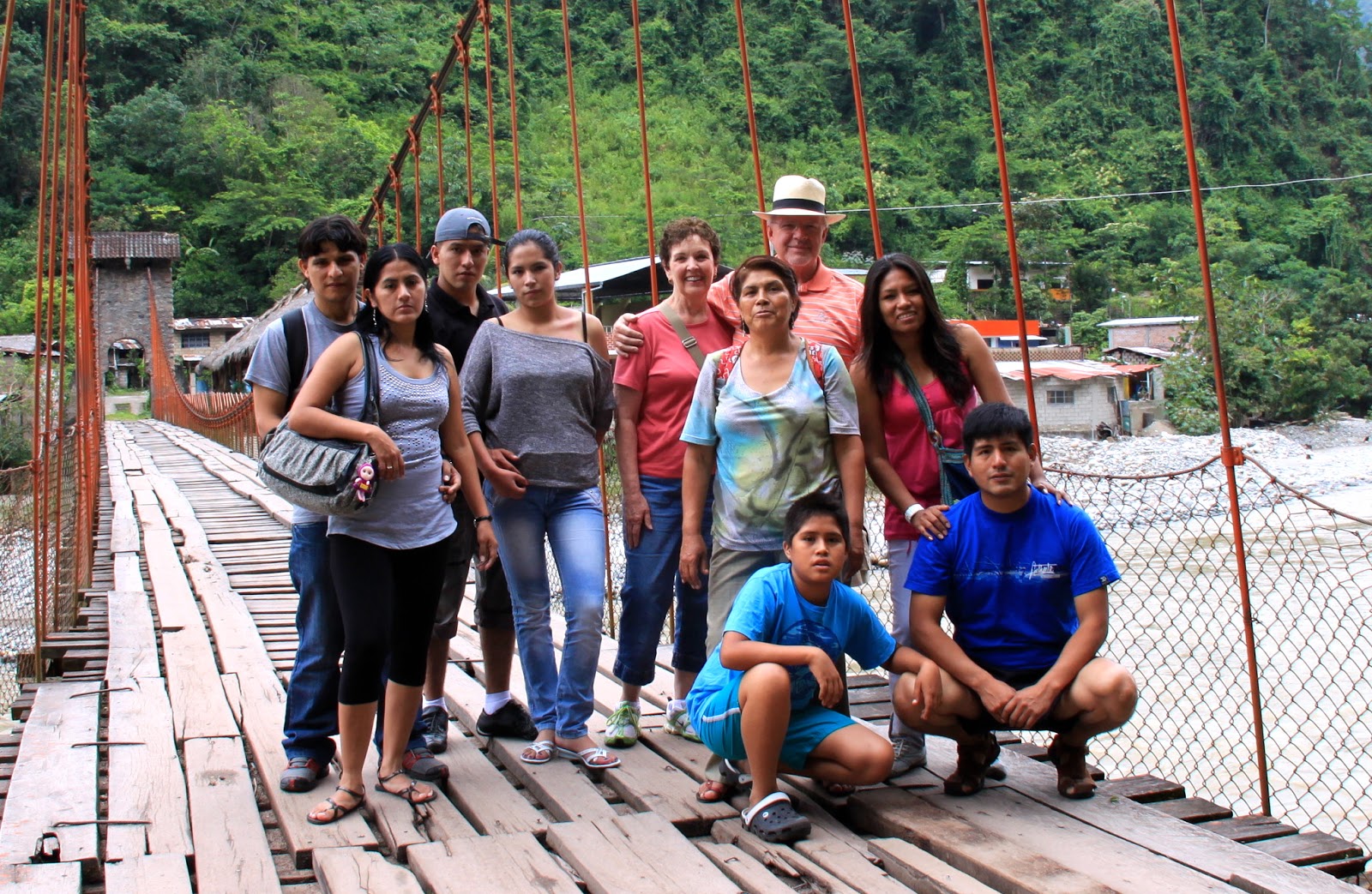
Our first stop was near the eastern edge of town.  We got out of the van beside a road side cafe, walking toward the Rio Perené.  There was a suspension bridge with capacity to drive a small vehicle, board slats running perpendicular to the length and track boards perpendicular to the slats.   The bridge swayed as you walked but didn't give an insecure feeling.  The river current below was moving very swiftly.  The span over the river measured about 150 yards.  On the other side we talked about the undergrowth of the vegetation and saw physical evidence of the extensive nature of vines growing from everywhere.  David told us about the history of the area. 
And the history is fascinating.  Perené district, was the territory of the Ashaninka culture for centuries, where they exchanged goods, cotton blankets, salt and wild bird feathers such as the parrot and wild animals native to the Andean.  Original man likely were The Turumas, pre-Inca culture, within whom there was a business relationship.  When it became more troubled they exchanged their products with the Incas.

In 1641, the river Perené was navigated first by missionary Francisco Matias Illescas who sought to evangelize the natives. There were many attempts to evangelize the Ashaninka by Franciscan missionaries, but they were expelled for trying to change the native way of life and religion, many of these acts were carried out violently.
For nearly one hundred years, the Central Forest remained closed for settlers and missionaries, following the failed attempt of evangelization and environment turmoil that existed in the territory.  In 1742 Asháninka saw Juan Santos Atahualpa lead a Revolt in the Jungle Central, especially for the territory of the district Perené.  In 1775 while driving back with the Franciscan missionaries he was killed by a native, who was hoping for his resurrection, because he was considered by the native community to be the son of God.

So the years passed, until the area was evangelized as part of the Ashaninka, ceding their territory to colonization thus benefiting Andean and European settlers.

In 1891 the Government of Peru, gave Cooper Pervian Corporation a concession of 500,000 hectares of land in the Perené Valley.

Between 1950 and 1960, organized groups of farmers from the central highlands decided to take possession of the lands of Cooper Peruvian Corporation, entering various sectors including Under Yurinaki and take possession of Florida region while others reached the bridge Quimiri Villa Amoretti, with others locating in Villa Anashironi, Port Victoria, Sotani, etc.

The jungle isn't as dense as imagined.  Undergrowth IS everywhere but the variety of plants depends on the terrain and rainfall of each specific area.  This area isn't flat and intensely overgrown but very mountainous with trees and plants everywhere although passable to walk through.  The tour started from La Merced Chanchamayo.  Our group included young couples from other parts of Peru.  Most were in their 20's or 30's.  As we drove away from the Plaza de Armas our guide (David) talked a little then asked us to introduce ourselves and tell where we were from and a little about us.  David spoke only Spanish except for some brief explanation of one provincial dialect used by one of the native village people.  It wasn't Cechuan (whose words we are a little familiar with such as  coca, condor, guano, gaucho, guanaco, Inca, jerky, lagniappe, lima [bean], llama, pampa, puma, quipu, quinine, quinoa, and vicuña.)
Next we visited a native village where we could listen to the stories from the natives.  Children and adults dressed in their native costume or not, came out to greet us and invited us to share their village.  They dressed us as one of them, painted our faces and shared their hospitality.  This area was fun to visit as were the others but people always take precedence over places. I could understand some of what he told us but not all.  We all felt his charm and openness to share his knowledge.  When I asked questions I spoke words that came to my mind after rehearsing the question before I spoke.  He understood mostly or asked me to repeat the question.  Language can be more of a problem if you let it be.  This wasn't the case for this trip.  David appears to be a native from a local tribe because of his height and facial features.  He wore his hair long and stood a little over 5 feet in height.  

 The Perené River (Spanish: Río Perenéon the eastern slopes of the South American Andes.
It is formed at the confluence of the Chanchamayo River and the Paucartambo rivers, 15 km above the community of Perené, actually two pueblos of Santa Ana and Pampa Silva divided by the river, at 650 m above sea level. It is formed at the confluence of the Chanchamayo River and the Paucartambo rivers, 15 km above the community of Perené, actually two pueblos of Santa Ana and Pampa Silva divided by the river, at 650 meters above sea level.
The river flows in a south-easterly direction; its length is 165 km. Downstream the Perené joins the Ene River, 10 km below the community of Puerto Ocopa, and is called the Tambo River until it flows into the Amazon.
At a naranja (Orange) plantation we overlooked the confluence of two smaller rivers high on a bluff.  Fresh orange juice was available for $.50 a glass.  Other fruits and berries also grew wild there.  I picked fruit from one tree that grew in bunches similar to cherry tomatoes but was sweet in flavor.  There was a large area to gather under a cabana where tables were nicely arranged.  The area was well maintained as compared to most of the others.  
 The next area we visited included two water falls (catarata).  The first was a little hike beside the roaring river coming from high up.  Footing was narrow and slippery but handrails had been installed.  The walk was no more than ten minutes before the trail climbed sharply upward clinging to the rock face against the river.  At the top was a beautiful waterfall with several layers cascading down.  Several in the group decided it would be fun to enjoy the water.  First the guys took off their shirts and in trunks walked into the shallow river toward a waterfall whose width was about 100 feet.  Water falling above this level from two more levels created a moisture and mist in the air that was very refreshing in the heat of the day.  I didn't join those who got in but took lots of pictures for them.    Below these falls was another falls known as 'Catarata Velo de la Novia'  better recognized as Bridle Veil Falls.  Walking down the trail along the fast moving smaller stream you could hear the sound coming up from far below.  As I approached the edge of the bank I could see the water cascading over the smooth rock river bed and down several hundred feet to the pool below.  The pathway ran along side the river to the edge then along the rock wall to the left then steps led to observation ledges below where I took several pictures.  The ravine below was lush with water flowing from two directions forming a much larger clear mountain flow.  

Each location was equipped with Banos or restrooms (bano means bath in Spanish so they refer to them as banos with some latitude for interpretation since most don't have a bath facility.  Vendors never miss an opportunity to exchange their wares or food for cash.  Fair included cherisos and fried plantane or banana.  Both were good tasting and safe to consume.  Water for drinking is generally regarded with caution.  Taking a water bottle filled with clean water is always a good idea no matter where you go.  In S.A. its double important so you can enjoy your travels free of stomach issues.  

Next we the return journey along the road stopping at a coffee plantation.  Prior to the plantation we stopped for dinner at one of the many set up along every town and village.  This one was marginal but the tour company must have had an arrangement with remuneration.  Then the plantation visit was next.    This stop contained visiting a processing location for coffee plus other commodities such as exotic liquors and chocolate. The chocolate was purely wonderful but the real purpose was to tell us about the liquor they made.  Samples were freely shared and most imbibed.  I chose some chocolate 100% cacao and helado (ice cream) for a treat.  What a fun day with some very nice people.  The feeling of being comfortable everywhere we travel seems unusual.  Our minds had been conditioned to be more cautious and untrusting.  Not the case.  Reasonable caution is still a good idea in more dangerous places.  This isn't one of those places.  

Monday, February 11, 2013

Thursday the 31st was an experience in the high country.  As said, the altitude in Tarma is a little higher than we're all acclimated to generally.  Lima is at sea level so when you climb to such great elevations acclimation is an issue.  Our first half hour out of Tarma took us back west and higher into the tops of the Andes.  From Lima we had traveled East and toward the continental divide.  Reaching the top and down toward Tarma the altitude reached very high at 15,800 ft.  Just as in the US, the continental divide determines the direction of the flow of rainfall into one of the two oceans.  Those tiny drops become little streams and collectively they fall from the most beautifully clear waterfalls as they cascade down the mountains.  These number in the hundreds on one river that flows progressively toward the Atlantic via the Amazon.  The Amazon Basin is the part of South America drained by the Amazon River and its tributaries that drains an area of about 6,915,000  sq. km. (2,670,000 sq. mi), or roughly 40 percent of South America. The basin is located in the countries of Bolivia, Brazil, Colombia, Ecuador, Guyana, Peru, and Venezuela.  Most of the basin is covered by the Amazon rainforest, also known as Amazonia. With a 8,235,430 sq. km (3,179,720 sq. mi.) area of dense tropical forest, this is the largest rainforest in the world, slightly smaller than the entire United States including Alaska and Hawaii.
High on the eastern edge of this Basin is the mountain plateau.   Because of its latitude, this elevation is unique where no trees grow, the only animals are those able to stand the altitude.  Llamas, vicuña, some sheep and really tough cattle are on the list.  The Altiplano (also known as Andean Plateau) (Spanish for high plain), in west-central South America, where the Andes are at their widest, is the most extensive area of high plateau on Earth outside of Tibet.Lake Titicaca is its best known geographical feature.
 The llama (English pronunciation: /ˈlɑːmə/; Spanish: [ˈʎama] locally: [ˈʝama] or [ˈʒama]) (Lama glama) is a domesticated South American camelid, widely used as a meat and pack animal by Andean cultures since pre-Hispanic times.
The height of a full-grown, full-size llama is 1.7 to 1.8 m (5.5 to 6.0 ft) tall at the top of the head, and can weigh between 130 to 200 kilograms (280 to 450 lb). At birth, a baby llama (called a cria) can weigh between 9 and 14 kilograms (20 and 30 lb). Llamas can live for a period of about 20–30 years depending on how well they are taken care of.  Llamas are very social animals and live with other llamas as a herd. The wool produced by a llama is very soft and lanolin-free. Llamas are intelligent and can learn simple tasks after a few repetitions. When using a pack, llamas can carry about 25% to 30% of their body weight for 8–13 km (5–8 miles).[1]
The name llama (in the past also spelled 'lama' or 'glama') was adopted by European settlers from native Peruvians.

A traditionally dressed Quechua girl with a llama in CuzcoPeru


Llamas appear to have originated from the central plains of North America about 40 million years ago. They migrated to South America about 3 million years ago. By the end of the last ice age (10,000–12,000 years ago), camelids were extinct in North America. As of 2007, there were over 7 million llamas and alpacas in South America and, due to importation from South America in the late 20th century, there are now over 158,000 llamas and 100,000 alpacas in the United States and Canada.
Using llamas as livestock guards in North America began in the early 1980s, and some sheep producers have used llamas successfully since then. They are used most commonly in the western regions of the United States, where larger predators, such as the coyote, are prevalent. Typically, a single gelding (castrated male) is used.
In the Inca empire, llamas were the only beasts of burden, and many of the peoples dominated by the Inca had long traditions of llama herding. For the Inca nobility, the llama was of symbolic significance, and llama figures were often buried with the dead.In South America, llamas are still used as beasts of burden, as well as for the production offiber and meat.
 Stone and adobe out buildings litter the landscape  in the high country.  The district of San Pedro de Cajas is one of the nine districts of the Peruvian province of Tarma, in the Junin region. The meaning of the word "box" comes from the word Cacas or Gagash meaning "rocks" to be located between rocks and scree, altitude 3.950 m Dry frigid climate and a population of 8.923 inhabitants. Most of the district's population lives in urban areas while more than 30% have agriculture as their main occupation. Among the major crops in the area include the potato and the other percentage is dedicated to craftsmanship that is the development of tapestry wool.  Among the traditional dishes include the pot and Jaka Locro.  Mr. Rodrigo Matos Mendieta, who conducted studies on the origin of the first inhabitants of chocolate or Junin plateau, specifying who must have been nomadic and settled by the abundance of food products of different origin, vegetable: the acshu, Quechua name of the pope, of different shapes and colors, plus the mauna shire and producing in adjacent streams, maca especially on high: quadrupeds: llama, alpaca, guanaco, vicuña, deer, Brocket, etc; rodents: vizcachas and guinea pigs, birds: ducks, aynos, huachuas, yanavicos, frailescos, whistles, partridges; ichthyological: catfish and frog.


A town in progress according to the thinking of the authorities of the time, felt that the municipal agent should have an office where citizens meet, with that concern local built a foundation stone, adobe walls, palisade and chacla of quinual and thatched roof, after some renewed fire accidents with corrugated roof. It was two floors, the first with the door that faces the square and two windows, the second floor with a door to the west connected by a flight of stone, an enclosed balcony railing balusters and by communicating with the interior one door and two windows overlooking square wing. At present this is the photo of the Municipaiidad of San Pedro de Cajas.

Near San Pedro de Cajas is a spring containing natural salty water.  In fact, there are two pools, one with clear salty water and one with brownish salty water.  We tasted both of the waters and found them equally salty.  The origin of this place is a place of worship with one pool representing the sun and one of the moon.


 A visit to a weaver in San Pedro gave us insight into art of making so many products from wool or alpaca.  The natural fibre is dyed using plant materials dissolved in water for days then soaking the fibre.  The bottles to her left show the hues of vibrant color.  Behind her are various tapestries.  We bought the one on her right shoulder for S/.100 or about $40.  Her time taken to make it was about a week.
Next Claudia tried her hand at rolling it into thick yarn for the weaving.  Rather than continuous strands in the weaving, sections were placed against a pattern died onto the loom strands to produce the tapestry.  Those behind her are good examples.  In addition she made lovely clothing from alpaca fibre then sold her products in her own shop situated beneath their home.
 This woman had such a gift creating the beautiful products on either her loom or by weaving by hand.  The shop was filled with products or in process projects and materials.  Her husband and family we involved in the work along with raising a garden, flower cultivation and Cuy raising for a little protein.  Just below are the stairs lined with flower pots leading to their home above the sales shop.  On a footprint measuring 50 ft by 60 ft this family flourishes.

 Our next side venture was to a cave spring deeply imbedded into the side of the hill from which water flows continuously.  A short hike along a flowery trail led to the mouth of the cavern.  Inside the flowing water ran next to a stone pathway.  Deeper into the cave a ladder leads to high rooms where stalactites and stalagmites forming interesting patterns.  Each was alive or colored rather than white limestone indicating the continuous nature of water flow.
The Andes is the longest continental mountain range in the world. It is a continual range of highlands along the western coast of South America. This range is about 7,000 km (4,300 mi) long, about 200 km (120 mi) to 700 km (430 mi) wide (widest between 18° south and 20° south latitude), and of an average height of about 4,000 m (13,000 ft). The Andes extend from north to south through seven South American countries: VenezuelaColombiaEcuadorPeruBoliviaChile andArgentina.
Along its length, the Andes is split into several ranges, which are separated by intermediate depressions. The Andes is the location of several high plateaux – some of which host major cities such as QuitoBogotáArequipaMedellínSucre, and La Paz. The so-called Altiplano plateau is the world's second-highest plateau following the Tibetan plateau.
The Andes range is the world's highest mountain range outside of Asia. The highest peak, Mount Aconcagua, rises to an elevation of about 6,962 m (22,841 ft) abovesea level. The peak of Chimborazo in the Ecuadorean Andes is farther from Earth's center than any other location on Earth's surface, due to the equatorial bulgeresulting from Earth's rotation. The world's highest volcanoes are in the Andes, including Ojos del Salado on the Chile-Argentina border which rises to 6,893 m (22,615 ft). Over fifty other Andean volcanoes also rise above 6,000 m (19,685 ft).

As we left Tarma, the greenery was ample but no lush.  As we came closer to about 5,000 feet in elevation it got more and more dense until it began to look overgrown.  Then from the density banana plants began to appear and taller and larger trees.  Often it was difficult to see into the thicket more than a few feet.  Water falls began to appear on both side of this narrow but very deep canyon into which the road was carved.  Many places the road had washed off into the raging river limiting traffic to a single lane.  Our driver, Gregorio was excellent, cautious and attentive to our needs. He talked with us about each new town or area as we passed through.  Much of what he said we could not totally grasp but on the whole we got what he had to say.  There was on place where a temporary bridge had been constructed allowing traffic to pass.  A massive rain storm had wiped out the original bridge sometime about 5 years ago.  The construction urgency is apparently not severe enough to replace it so the temporary span is doing the job.


Amazon River basin (the southern Guianas, not marked on this map, are part of the basin)

The mouth of the Amazon River, the second longest[1] river in the world.

This route is a principle transport link from the farms and their production of fruits and vegetables as well as replacement parts, products from Lima and other needs.  I estimate the traffic is 95% commercial in some way or another.  Trucks carrying well over 20 ton passed us often headed back up to Tarma and on to Lima.  Other commercial vehicles included smaller trucks and taxis.  The traffic is continual night and day.

One transportation method employed by the sedan type taxis is the 'collectivo'.  This arrangement is made to accomodate the needs of the traveling public as they attempt to travel and share the extra room in vehicles.  Several people will jointly hire the auto because of the time and destination then share the cost that previously was born by fewer riders.  As an example, we hired a vehicle without using the collectivo concept and paid about S/.100.  The driver could have sold any extra seats and increased his revenue or reduced our per person cost.  Collectivo arrangements are a common widely used method of  cost containment.  The only drawback for foreigner is finding them.  Travel knowledge is more tribal here but talking to locals is one of several keys to finding good transportation.

From our place in San Ramon we can see directly into the most dense jungle.   Guides will be the safest and most sure way to access and learn the most for now.  Most common sights are freely accessible.  Finding them and learning details is the key for foreigners.


Friday, February 1, 2013

Our travel this maintenance break is to the Junin Province where cities like Tarma, La Merced and other beautiful places are located.   This Province is in the central highlands ofPeru. Its capital is the city of Junín.  The territory of the province is mountainous and it includes Lake Junín, which is the largest lake entirely on Peruvian territory, and the second-largest lake in the country after Lake Titicaca. Among the most important rivers are the Mantaro and Ulcumayo rivers.  The Junín Province is divided into four districts (Spanish: distritos, singular: distrito), each of which is headed by a mayor (alcalde): The Junín Province is subdivided in four districts:

Santa Ana de la Ribera de Tarma is a city in Junín RegionPerú. Tarma is the capital city of the Province of Tarma, and is also called the Pearl of the Andes. The city is located at an elevation of around 3000 m.(10,016 feet) The regional population is of around 123,350 inhabitants while the city of Tarma has a population of 60,542.

File:Tarmaperu1.JPG

At the beginning of our trip on Tuesday the 29th of January 2013, we hired a driver to take us to the station. Our destination is the bus station in central Lima.  It will take 35 minutes or so.  We don't want to be late so we got an early start.  The station is located in a poor commercial section with broad sidewalks and garbage collected on every corner.  The people don't let the sun catch them sleeping here ever.  Most Peruvians do not own a personal car but take some form of public transportation.  Taxi cabs, rickshaw taxi's and buses are the most common.  Rickshaw taxi's are found in poorer neighborhoods.

Inside the bus terminal we are approached by a vendor selling handicraft items.  This woman is selling necklaces and bracelets she has made from natural materials all found in Peru.   A necklace with a jaw of a Piranha fish with lots of little razor sharp teeth along with red good luck beads and many other beads.  You can see from the picture she has an inexhaustible selection.  I talked a long time with her asking the names of all the beads and where they came from but will never remember it all.  
 As in every kiosk shop with a permanent counter, this portable kiosk vendor has a little of everything a traveler would or could want or need.  Most people are such good people with so little to live on.  They really are entrepreneurial however.  They all work at something and do so very diligently.  They are not shy nor are they timid or self conscious.  This fellow has a wife and child to support.  He seemed to be doing a good business at this location but will move around much throughout his long work day.  Others shine shoes, sell food ready to eat like vegetables or fruit.  Sandia (watermelon) can be purchased by the slice in clean plastic paper along with pineapple slices or bananas.  


These offices are transit hubs to the traveling unwashed masses of many countries.  Unloading is a spectacle.  Most transit times exceed 10 hours with families traveling together.  Cargo hold contents include animate and inanimate food.  Chickens are everywhere, in cages and sacks being monitored by 12-14 year old youth.  Vegetation includes the produce found at the home location of the traveler.  Bananas, limes, and oranges just to name a few.  These will be sold in Lima for living money.  The process will repeat itself often.  Lima with its 10 million people can be a very attractive market.    

 The trip to Tarma takes about 6.5 hours on the best day.  This trip wasn't on the best day.  From sea level the curvy switchback road climbs slowly to the summit at 15,800 feet then descends into Tarma whose elevation is 10,000.  Combine altitude with endless stop and go, rock and roll driving and road sickness for a perfect nausea.  After short naps at our great hotel Los Portales in Tarma, some late dinner and good sleep we awoke feeling better and ventured into the town to visit some of the locals.  These two ladies were eager to speak to us.  They were carding wool for yarn.  Close up discussions showed hard lived women who have remained warm and friendly.  We held their hands and talked for a few minutes.
 Then asked their permission to take their pictures for recording this experience for our posterity.  

The daytime temperature is 70 then add the sun exposure and its a warm day.  Clothing options seem never to vary across the entire population of women.  These older woman wear layers then add a blanket for extra comfort.  Hat's are warmth and shade but seldom pertain to geographical or family groups.  
 Tarma streets are narrow consistent with most of the towns we've visited.  Shops are always small and simple.  Each caters to one specific product or service.  Pharmacies are the most numerous with several per block.  Food stores, internet cafes, copy shops, bakeries and stores selling clothes.  Patrons are strolling scarcely around for a Wednesday.  Ice cream vendors peddle their vendor cards with their frozen concoctions throughout town as witnesses to the craze for being self employed.  No less than 4 per block meet you constantly.  If you make eye contact there is a presumption of a sale about to take place.  
 Near the busier section of the shopping district sat three men, one in front of a manuel typewriter.  Being curious about what goes on behind a manuel typewriter I asked if it was his 'computedore'.   He laughed and said he did papers for tourists.  I didn't ask what kind of papers he prepared but introduced myself and asked their names.  Jose on the left was a little quiet, Manuel was behind the typewriter and Willy is the one with his hand in the air.  They told me they were just a bunch of not so young men.  I told them youth is overrated.  Very happy men who told us more about the town.  
 Since this part of Peru is so close to the Equator the weather is generally warm unless the location is at greater altitude.   Tarma is situated at a relatively low altitude when compared with the many peaks above 20k feet.  The joy of exploration is discovering new places and things for yourself is new to each of us.  Wether we are the first or the 500th to discover something its new to us and we take it in individually.  
 In every city in Peru, areas have been designated as parks for relaxation or play.  Flowers adorn every one of these parks.  The flowers and other plantings are always personally managed.  Every one is cultivated, irrigated, trimmed and planted regularly.  Since the seasons are always good for these gardens, the flowers, trees and shrubs are blooming every month of the entire year.  Plantings are always so colorful and fresh.  Gardeners are both men and women who are employed by the local jurisdiction.  They wear uniforms all bundled up in long sleeves and masks for their faces to protect them from any dust created.  
 The trees are all tropical ones.  What may appear as a pine tree is more a silky needled pine looking one.  The exact type of tree in this picture, the one on the far right, is most fascinating to me with pine needle like leaves but is so fine and delicate that it must be oriental in origin.  
 Claudia enjoys these travels too.  We have plenty of company wherever we go and feel the security and comfort of good people everywhere.  This park has many large palms that must be many years old.  Whether palms are indigenous to this place is hard for me to believe but tomorrow there will be a tour of areas with guides to explain the flora and fauna in more detail.
While Mom sits working on handicraft, this little 18 month old entertains herself with scraps and never acts up.  I talked with her mother so I could learn her name and age.  Now I can't remember her name.  I must have a head for numbers only.  Her ready smile told me she is greatly loved by her family.
 Returning from the guide service planning for tomorrow I captured Manuel and Jose continuing with their work typing documents for tourists.  Manuel makes his living with this ancient instrument.  Life does exist without computers in some places although the internet cafe across the street was doing well.
 Open markets cater to tourists giving local crafters a chance to turn their labors into real spendable money.  Examples of prices:  full knitted coat $12, coin purse made of leather $2, baby alpaca scarf $4, bottle of water $.60.  Labor is so inexpensive and so plentiful.  Supply and demand principles are true everywhere.
 Volkswagons are more plentiful in Peru than any place we've traveled.  This one has received just about the ultimate modifications.  I suspect its all for show with little or no functional value.  Remember that cars per capita in all of Peru is 68 per 1000 residents compared to 812 in the USA. Taxi cabs outnumber personal vehicles here just like they do in NYC.  The difference is in their appearance and comfort.  Taxi's are merely a means of getting around for people but in addition they carry significant cartage in the form of vegetables, parts and product.  This little guy is a personal vehicle.  No taxi cabs are VW.
Other scenes in Tarma reflect a little more of the lives of the people.  People are generally industrious and hard working.  Work here is more survival than enjoyment yet time doesn't appear to be any pressing issue.  Deadlines are mere suggestions to most.  Appointments are more casual in nature.  If the appointment is written down the chances of real action are better but still not absolute.  Living takes priority over working.  Parents do not leave their children to other to tend but carry them on their backs or hold their arms when walking.  Elderly people are well cared for as mother daughter scenes are plentiful.
Streets in Tarma are all narrow except for a few thoroughfares with boulevard dividers.  Flowers abound here except on the narrow streets.  This scene reflect the diversity of city, arena and mountainside all compressed together.  Building methods are consistent with every city we've visited.  All structures are made from ceramics of one kind or another.  Mostly the material of choice is concrete with ceramic tile facing of stucco like material.  Paint is applied as an afterthought while ceramic materials are artfully applied.  For more public viewing most surfaces are tiled.  This green wall is not that intent.  Wood is sparingly used and generally for door or window frames when metal isn't used.    Notice the electrical wires strung from a concrete telephone pole.  These trades are applied more conveniently than according to any building trade code.  Wires for electric or telephone resemble confusion rather than planning but non the less internet and telephone connections are a primary need for these wonderful people.